Description
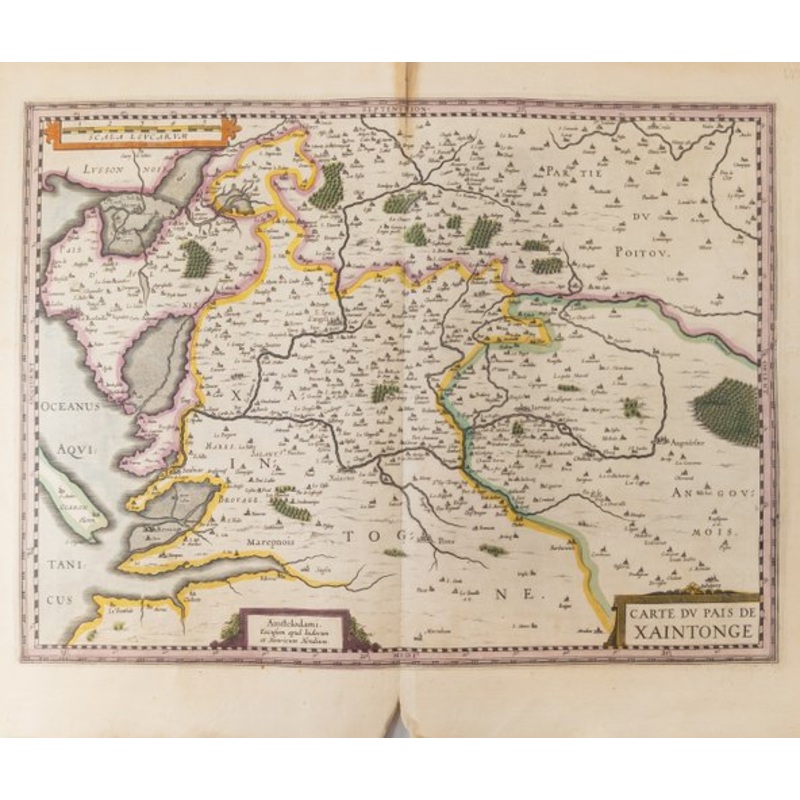
We are selling this 17th century Hand Colored map of Saintonge France. Pais de Xantoigne / Amstelodami, excusum apud Iudocum et Henricum Hondium | Title: Carte du Pais de Xaintonge | Authors: Jodocus Hondius & Henricus Hondius | Date: 1619 – 1628 | Type: Atlas [Topography] | Published: Amsterdam, Netherlands.
Condition: Some fauxing a few areas of staining and browning. Separation down the central crease.
Dimensions:
Height 18 1/4 Inches 46.4 cm
Width 21 1/2 Inches 54.7 cm
Impression Height 15 Inches 38.2 cm
Impression Width 20 1/4 Inches cm
| Design Period | Before 1890 |
|---|---|
| Production Period | Before 1890 |
| Country of Manufacture | Netherlands |
| Style | French, Renaissance |
| Detailed Condition |
Very Good This vintage/antique item has no defects, but it may show slight traces of use. |
| Restoration and Damage Details |
Light wear consistent with age and use, Patina consistent with age and use, Some fauxing a few areas of staining and browning. Separation down the central crease.
|
| Product Code | TCM-1981711 |
| Materials | Engraving, Paper |
| Color | Ivory |
| Width |
55 inch 21.5 inch |
| Depth |
1 inch 0.1 inch |
| Height |
47 inch 18.3 inch |
| Duties Notice | Import duty is not included in the prices you see online. You may have to pay import duties upon receipt of your order. |

Reviews
There are no reviews yet.